This seems like a bit of a nightmare really. Not sure whose going to pay for magic earth when Waze and Google Maps are available. Didn’t /e/ os fork it?
I’ve never used the other two options but I wouldn’t include OsmAnd as a default maps app. Its very very heavy and not straightforward to get going with.
If nothing fits maybe don’t bundle a maps app, for now.
Its a shame magic earth have gone this way. Only app other than Waze that allows reporting of hazards, police traps, etc
Well at $1 / year for Magic Earth, if CoMaps wouldn’t meet my needs I would happily pay that to use a more privacy respecting option over Google Maps or Waze.
Often the open source approach of bundling the most accessible option (but erring on the side of being too simple) is preferred because more advanced users will know how to add their own option (and can decide if they want to pay $1 or instead use and trust Waze, Google, etc). Yes it may not meet the needs of all, but bundling more proprietary apps than necessary is more of an issue.
As I say often, even if a company seems ethical, if the source is closed you simply can’t know for sure what it is doing under the hood. Exposing all iodé users to that is the bigger risk.
Unfortunately, you can’t control everything, but it’s clear that if you don’t pay, you pay with your data.
MagicEarth did not collect any data from me or my smartphone, was free of charge and delivered an excellent program. Anyone who asked was given a link to download the program directly from MagicEarth to avoid Google. Now I have to pay a small fee, which I think is fair.
That’s why I prefer to pay a small amount to get a program, an app. That’s why I also use Threema.
I think I also pay for iodé, just leave navigation out of the pre-installed apps.
You may be able to update to Maps+ and OsmAnd Pro within the app, but I don’t think it’s free.
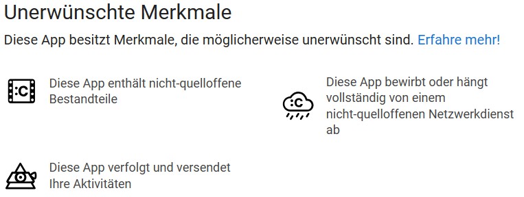
The reference to the unwanted features is also worth reading…
It certainly is free. The OsmAnd~ app from F-Droid is OsmAnd+, but free. I have it insatlled on all my devices, and all the mentioned features seem to work fine.
Indeed. It makes clear that the F-Droid version is built from source, with the ‘UpstreamNonFree’ features (including Google & Amazon Pay and in-app purchase) removed.
UUID is anonymized randomly generated key per installation, cause this key is not associated with any advertisement id or not transferred to any other 3rd party or even used, this key doesn’t require consent. As you mentioned the IP could provide more information cause it’s location specific.
This approach helps to the server monitor fair usage of resources.
First of all, connecting to the server is only something that
happens during download. OSMAnd is an offline map and downloads
happen rarely. For heavy users less than once a month, for many much
less than that. Additionally, all such downloads are user-initiated,
they have to explicitly press a download button. Nothing that would
be useful to build a profile of any specific user.
Allegations of travel data and such being leaked are thus really not
in evidence.
The data that is being shared is not possible to connect to any
personally identifying information. Notice that google explains that
since some 5 years the getUserAndroidId is unique per installed
application. So any other application the user uses (on the same
phone, or not) will not share the UUID. So on top of the fact that
not much of a profile can be made at all, there is no way to connect
such to any actual personal info.
So, IMHO this is not a big issue, and not sufficient reason not to use OsmAnd. Though in the poll I voted for CoMaps not OsmAnd. I am just challenging some inaccurate statements about OsmAnd, such as
All the features of OsmAnd+ are available for free in OsmAnd~ from F-Droid
In my opinion future IodeOS should not provide a default (naviagtion) app, as no app suits the needs of all the users.
There is no app that has low battery usage, accurate traffic information and maps, hazard warnings, speech in / out, fast and situation aware routing with mixing of transportation channels, without trackers, without unwanted features, without ant-features, without adds, open source, for free, activly maintained …
Also any app you choose has to be judged by the same rules like the paid iode blocker.*
*When i joined iode the blocker was not open source and it still can not be deinstalled like magic earth. So arguments like “open source”, “paid” and “trust” are not valid here as people use paid closed source apps that promise privacy or otherwise fulfill thair needs that free apps don’t. Most probably no one has checked the source code of the os and the default apps. We trust the developers and use IodeOS/Magic Earth/Threema …
Agree. Of many of the apps listed here, I have found that Magic Earth is much more reliable in my area. The FOSS ones are all listing POIs that are 5 years out of date… institutions that just dont even exist anymore.
For a buck a year… and no Google, I’m fine with that.
CoMaps is fork of Organic Maps and don’t bring any new feature. I don’t understand whay is selected for default navigation apps CoMaps instead Organic Maps.
If Organic Maps project is not supported, it will soon be dead, all fork also with time will be dead. I fear that the last bastion of free navigation is falling.
That sounds funny to me, because Magic Earth and CoMaps are both relying on OpenStreetMap data, right? So like people are adding reviews to places in Google Maps, I started updating POIs in my area via CoMaps, Streetcomplete and Everydoor. With StreetComplete it really is fun and a lot of people and apps are profiting off it
This isn’t quite accurate. As a fork there is no reliance on Organic Maps themselves. Devs with CoMaps are able to move forward, again the data sources are Open Street Maps, not Organic Maps. So think of this like LibreOffice being a fork of OpenOffice. OpenOffice has long since been stagnant, but that doesn’t restrict LibreOffice development and health (except for the confusion that many will try OpenOffice due to name recognition, find it outdated and buggy, and then will not find or consider LibreOffice before deciding that the alternatives to MS Office are not up to par and go back to MS).
I think you may be thinking of something more like a derivative, such as Ubuntu based on Debian, or Linux Mint based on Ubuntu (or their LMDE spin based on Debian). If Debian goes away, Ubuntu and Linux Mint would be in big trouble (because Ubuntu and Linux Mint are not forks of Debian). If Ubuntu goes away, the main Linux Mint spin is in trouble, but they switch to their LMDE spin as their main release. The point in all those scenarios are that the full code base is not a fork, it is all the custom bits based on upstream.
In our own case, if LineageOS goes away, iodé would be in trouble, we are not a fork of Lineage, we are further customization built on top of Lineage.
Now, to further muddy the waters, since the upstream projects are all open source, if any of them go away, then a fork of them could occur. But it would be a huge effort to maintain that would need a lot of support (development AND funding). So back to CoMaps, as a true fork they do have the full workload of maintaining the code base, so they do need support to do this.
If compare with OpenOffice and LibreOffice, You know (or I think) LibreOffice have lots new features, more options for adjust.
If Compare Debian vs Ubuntu, Debian is more traditional distribution, Ubuntu develop own GUI and more user friendly for new linux users
LineageOS is basend on Android Open Source Project and Iode project have new features for control privacy and data monitoring
In all case, all fork (case 1-3) bring some new stuff, lets back to CoMaps vs Organic Maps, CoMaps have zero new features. Ok I need corect myself have automatic export of bookmorks file and that is all. I expect from new fork new feature in this case for example “pre-recorded” voice for navigation. That feature missing from Organic Maps / CoMaps. Text to speech works very poorly.
You can agree with me or not, I’m just telling the facts. I’m here if you want to debate.
I understand your frustration if there are some significant advantages to Organic Maps. But please keep in mind that it was put to poll and the community decided to go with CoMaps. This is a low-stakes decision, as the preinstalled apps are merely there so that average users can have a device with at least one option already installed, but that there is no lock-in. Anyone can simply uninstall the pre-installed apps from the android app configuration settings and install whatever other apps they need from Aurora or F-droid, or another app store.
It’s not about my frustration, I’m honestly not frustrated. I just know Iode can do better.
I suggest that we take a good look at what’s being put to a vote, because of the three choices, we have two identical apps (Organic Maps and fork CoMaps which is identical to the original app) and Osmand.
I agree with you that nothing is locked and can be easily uninstalled and installed any other alternative navigation which is extremely good and for every praise.
You do a great job and I support your work and effort (I bought a mobile phone through your webshop, a lifetime subscription for my family, etc.). If I’ve been critical, it’s only for the purpose of improving and understanding the users who use your product.